Navigon

Διαθέσιμο από AppStore
$94.99 Introductory price
Περιγραφή:
IMPORTANT NOTE: This special introduction price is valid only until June 30th.
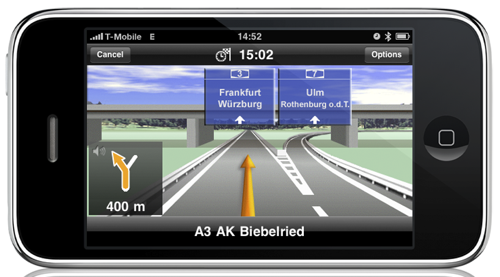
With the NAVIGON MobileNavigator you can transform your iPhone into a fully functional mobile navigation system that is every bit as good as the multi-award-winning personal navigation devices from NAVIGON in terms of its user-friendliness and features.
Thanks to a faithful adaptation of the menu functions, the NAVIGON MobileNavigator fits in seamlessly with the operating concept of the iPhone. The application includes the latest map material from the market leader NAVTEQ and can be used without an Internet connection, which is of enormous benefit abroad, for example, as no extra charges are incurred.
Features and range of functions:
- Simple, intuitive user interface
- Can be used in portrait and landscape format
- Precise voice announcements
- Intelligent address entry
- Reality View Pro (realistic display of motorway interchanges and exits)
- Lane Assistant Pro
Real signpost display
- Speed Assistant with adjustable audio-visual warning
- Day and night mode for map display
- Direct access and navigation to contacts saved in the iPhone’s address book
- The latest NAVTEQ map material
- Navigation is automatically resumed after an incoming phone call
- 2D and 3D map displays (bird’s-eye view)
- Quick access to user-defined POIs in the area and along the route
- Take Me Home function with a single click
- Automatic language selection to match the iPhone’s user language
Included maps:
Albania, Andorra, Belarus, Belgium, Bosnia-Herzegovina, Bulgaria, Denmark, Germany, Estonia, Finland, France, Gibraltar, Greece, United Kingdom, Ireland , Italy, Croatia, Latvia, Liechtenstein, Lithuania, Luxembourg, Macedonia, Monaco, Montenegro, Netherlands, Norway, Austria, Poland, Portugal, Romania, San Marino, Sweden, Switzerland, Serbia, Slovakia, Slovenia, Spain, Czech Republic, Hungary, Vatican
Languages:
English, French, Spanish, German, Italian, Swedish, Danish, Norwegian, Finnish, Dutch
Further languages and functions will be available soon in a free update.
Detailed information on the individual functions, maps etc. is available at:
http://www.navigon.com/iphone
Whether in the car, by bike or on foot, NAVIGON hopes you have fun navigating.
Screenshots:


